Transportation Infrastructure
Florida Keys Hurricane 1935
Windley Key
(The Umbrella Keys)
Windley Key is the pair of islands that are between Snake Creek and Whale Harbor. The two islands are now officially one island, having been joined together with railroad fill. It was reported to have been named after a settler, and has also been called Windly’s Key, and Vermont Key.

Before the railroad arrived, the two islands that now form Windley Key were called the Umbrella Keys.
While the waterway between the two Umbrella Keys would have been effective at releasing storm ebb current (due to having a Bay side catchment and wider gap between the two islands at higher storm surge heights), during non-storm conditions it was shallow and narrow, likely making it of little interest to visiting large boats that needed to look for deep water passages. Therefore, early nautical charts, mainly used by visiting large boats (instead of locals), did not show a passage between the two islands.
Nevertheless, naming it as a plural of more than one Key may have been intended to help convey the possiblity of small craft passage.
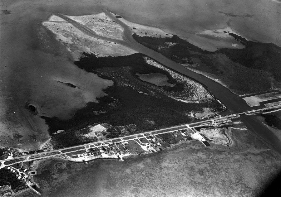
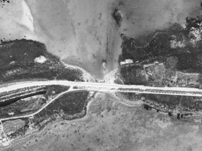
The portion of highway dike between the two islands of Windley Key could be removed and replaced with a bridge to restore storm ebb current capability under the bridge. Recreational opportunities could include launching smaller boats to explore mangroves.
Umbrella Effect
Consider the idea behind using an umbrella. An umbrella has a water repellent membrane that is convex toward the rain and concave toward the object to keep dry (a person or thing).

Even an umbrella that is crumpled at the top will help.

Now, rotate the map of Windley Key so that its Atlantic coast is up:
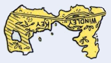
Notice how it looks like a crumpled umbrella.
Next, consider storm surge waves hitting it from the Atlantic:

Most of the waves would try to bounce back. Windley Key is like an umbrella against the Atlantic Coast waves.
Consider if there was a gap for water to flow between the two islands, like there used to be. Some waves from the Atlantic would go through that gap, but many of the waves would be reflected away from the gap.
What is actually happening is that each wave generates reflected waves in multiple directions, and for most of these waves the multiple directions will be back toward the ocean.
Now consider storm ebb current in Florida Bay flowing toward the Atlantic Ocean. The Bay side of the two islands would reflect waves more toward the gap. Each incoming wave reflects in multiple directions, with more of those directions toward the gap, due to the concave orientation of this side of the two islands which forms a waveguide.
References
“Giant umbrellas shift from convenient canopy to sturdy storm shield”, Princeton 2020
Florida Keys Hurricane 1935
Page 2 :
Page 3 :
Page 4 :
Page 5 :
Page 6 :
Page 7 :
Page 8 :
Page 9 :
Page 10 :
Page 11 :
Page 12 :
Geography
Railroad
Bridge Design
Hydro-Geomorphology
Marine Navigation
Planning
Snake Creek
Windley Key (this page)
Whale Harbor
Matecumbe
Long Key
Return to: Architecture, Engineering & Construction